Infrastructure & Competitiveness Viewed Through The Wheelhouse And Beyond
Captains, pilots and towboat crew members depend on the right tools to do their job safely and efficiently. Those tools include experience, mentors, safe and reliable equipment, training, communication with other towboats, radar, technology, aids to navigation (or ATON) and many others.
When discussing the infrastructure of inland waterways, the focus is often on levees, locks, dams, dykes and navigation channels. However, ATONs are equally vital components. They play a crucial role in ensuring that towboat captains, pilots and other waterborne operators can safely navigate any waterway.
If navigation is safe, then the food, fiber, fuel and feedstock of the U.S. economy will get from its place of being loaded to a position of discharge in the most efficient and safest manner. Much of that depends on well-positioned and well-maintained ATONs.
Coast Guard Keeps Industry Alert And Safe
The U.S. Coast Guard is responsible to “safeguard” the U.S. Maritime Transportation System. Its responsibility ensures uninterrupted flow of maritime commerce across 25,000 miles of navigable waterways. In safeguarding the waterways, the Coast Guard depends on a federal fleet of 50,000 ATONs.
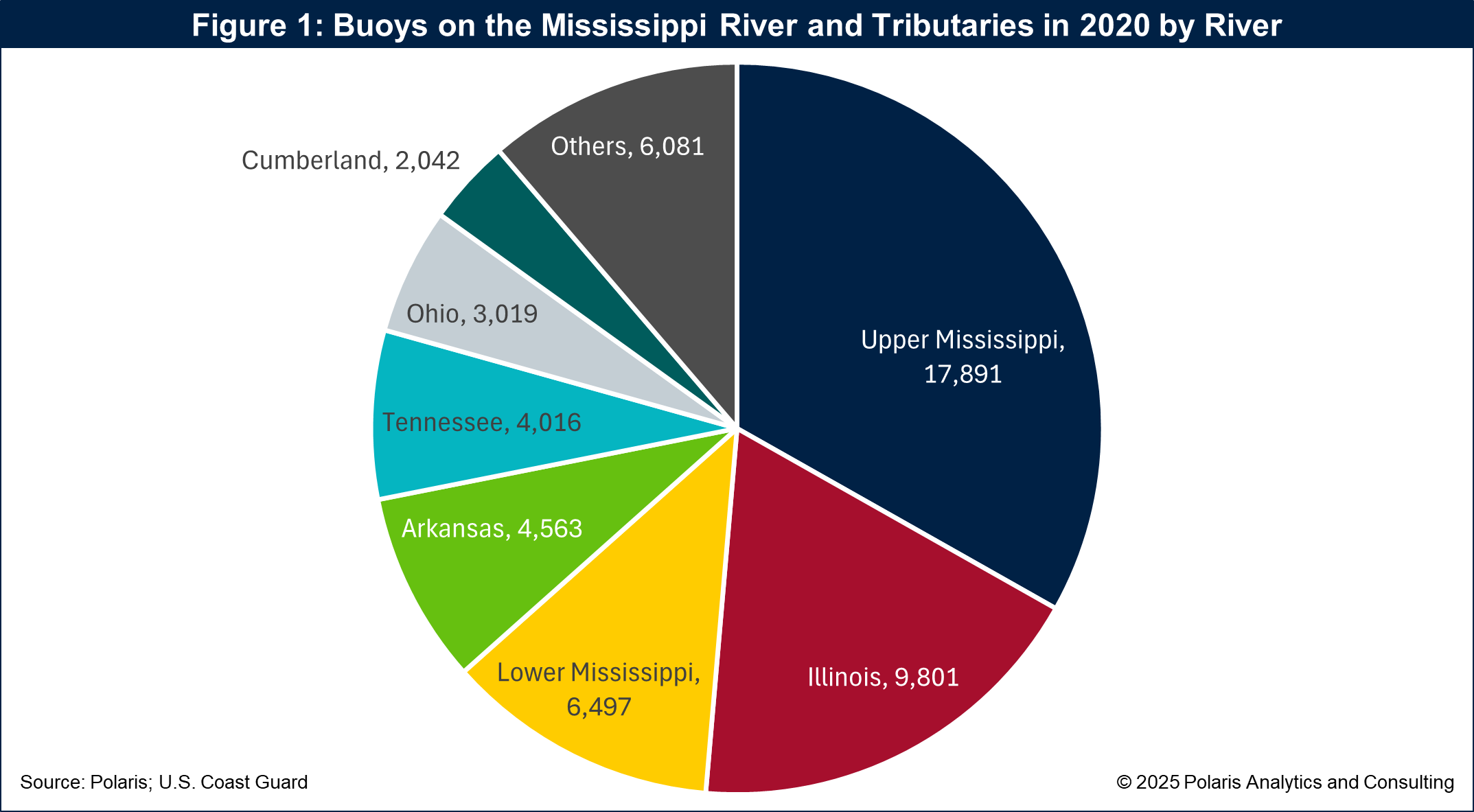
ATONs on the Mississippi River & Tributaries system (MR&T) include buoys, beacons, day markers, visual ranges, fog signals, radio towers and electronic systems. Buoys are used to mark channels, indicate hazards and safe waters. On the MR&T alone, the Coast Guard keeps up with 53,910 buoys, with 33 percent located on the Upper Mississippi River, 18 percent on the Illinois River and 12 percent on the Lower Mississippi River. Beacons can be fixed or floating and are used at night or during low visibility conditions. Electronic ATONs include GPS-based (geographic positioning systems) tools that provide real-time navigation conditions and information. Those ATONs require constant upkeep, maintenance, repositioning, etc.
The Coast Guard maintains a fleet of buoy tenders and ATON boats to inspect, maintain and replace buoys and other aids across the river system. The fleet includes 22 buoy tenders for inland and rivers and 160 ATON boats. These fleets are aging, with the average age well above 55 years and the oldest more than 80 years old. The Coast Guard has awarded contracts to build new vessels to replace the aging fleet. Fleet replacement will make certain that the most advanced and reliable equipment will be available to keep navigation safe and support keeping the economy flowing.
For towboat crews, having accurate and readily available information and data on navigation conditions is paramount to their safety and the economic vitality of the MR&T and the industry dependent on it. During any given year there are various conditions and events that impact navigation.
Low Water and Hurricanes
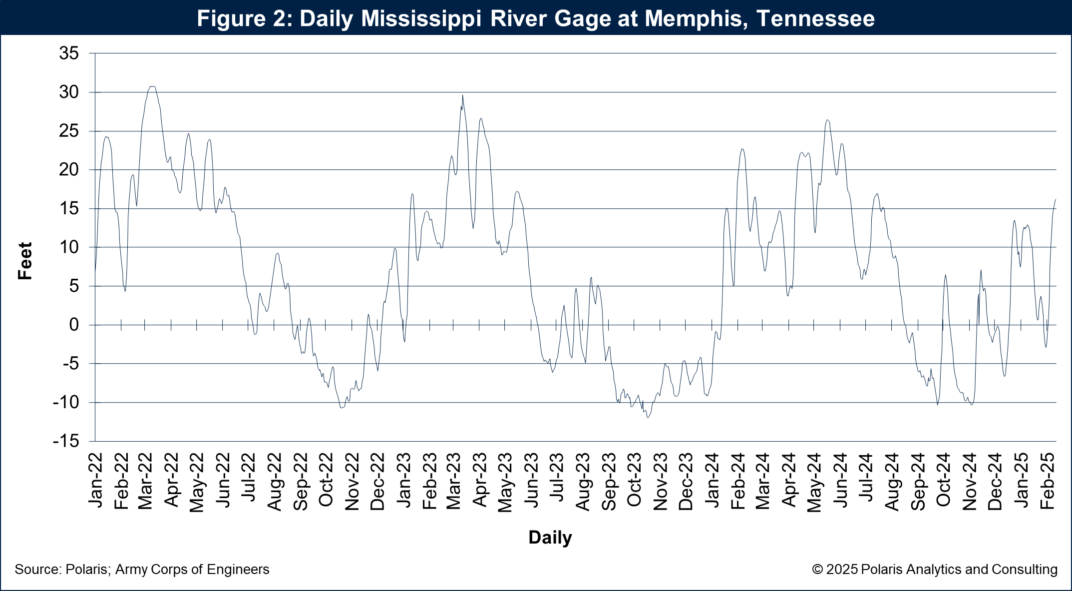
The hot, dry conditions during the summer and fall of the past three years led to low water levels across many segments of the MR&T. During 2022, the first of the extreme low water years, the Mississippi River water level gage reading at Memphis, Tenn., hit a historical low of -10.5 feet during October. That low water event was accompanied by slower water volume and a narrowing of the available navigation channel, limiting tow sizes, tow speed and the volume of commodities loaded per barge.
During the low water event in 2022 (and other challenges to navigation), the Coast Guard worked together with the Corps, towboat operators, industry participants and state and local agencies to ensure safe navigation channels and repositioning of ATONs to mark those channels.
As the water levels were dropping, Hurricane Ida came ashore in Louisiana up the Mississippi River Ship Channel, impacting vessel operations from Southwest Pass to Baton Rouge, La. Again, the maritime industry, including the Coast Guard and Corps, worked to ensure safe navigation conditions, which required keeping ATONs functioning and well positioned.
The worst of the low water events during 2022 were alleviated through timely rains and a melting snowpack from upriver locations. Then, low water returned during 2023, and the Memphis gage reading plummeted to a new record low of -12.0 that October. As with the low event in 2022, timely rains and a melting snowpack brought relief.
In 2024, for a third consecutive year, low water returned and the gage at Memphis hit a low of -10 feet. Conditions could have worsened if not for the water that Hurricanes Francine and Milton brought to the Tennessee and Ohio River valleys providing relief for the Lower Mississippi River.
The question on many people’s minds is this. Will this be the fourth consecutive year of low water? Only time will tell, but the tools of the system will be great to use and incorporate into one’s toolbox to keep abreast of conditions. The daily Mississippi River gage reading at Memphis is shown in Figure 1.
In each of these events, having open lines of communication and proper tools, including ATONs to navigate the river channels, were paramount. The availability and use of ATONs are a tool towboat captains, pilots and crewmembers use to keep the economy moving ahead.
ATONs Reach Beyond the Wheelhouse
But it is not just the crews of towboats that use and depend on ATONs and other tools monitoring the navigable waterways. Towboat companies, shippers, market participants and government agencies monitor the available signals or data streams from the MRT. Those signals or data include gage readings, water flow, velocity or discharge, Automatic Identification Systems or AIS, market conditions such as commodity supply and demand and freight rates.
AIS is a powerful tool. According to the Coast Guard, “AIS is a shipboard broadcast system that acts like a transponder.” AIS transmits certain information, including the name of a vessel or non-movable object, and sends out a signal on the course and speed, classification, call sign, registration number and other information. That information is publicly available.
AIS allows a person to see information that radar cannot offer. The use of AIS is powerful not only for towboat crews but also shoreside participants. Applications using AIS data are extensive, and when used with other industry data and information, AIS allows the industry to anticipate forthcoming events that are on or will be over the horizon.
It is not farfetched to see how deploying tools that use information from ATONs, water levels, currents, AIS, market conditions and other systems can be helpful in managing towboat and barge fleet utilization more efficiently. In an era of higher costs to build equipment such as towboats and barges, available data and technology offers towboat and barge operators and owners, shippers and market participants ways to enhance competitiveness in the global marketplace.