
Corps, TVA Minimize High-Water Impacts
While unregulated streams and rivers caused flash flooding in the Tennessee, Cumberland and Ohio valleys in recent days, close coordination between the Corps of Engineers and the Tennessee Valley Authority (TVA) helped to prevent some major downstream flooding.
Tennessee, Cumberland Rivers
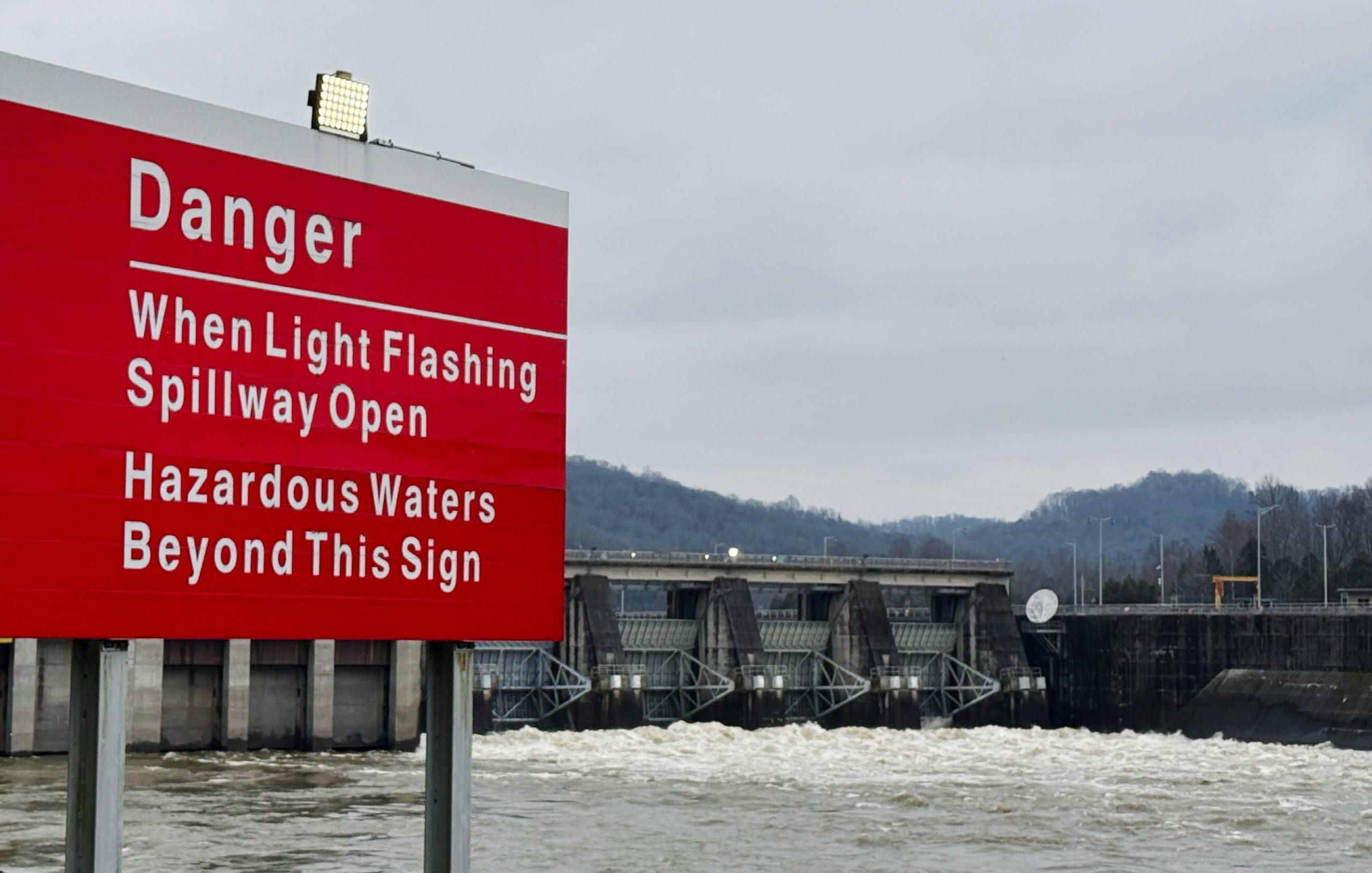
Impacts to navigation included the closure of Cheatham Lock, Cumberland Mile 148.7, on February 15 due to high flow. The lock reopened February 19. A Coast Guard advisory indicated that, until the flow rate at the dam falls below 75,000 CFS, tows must be no more than 105-by-95 feet, including the boat. No barges will be allowed “on the hip.” Additionally, tows must enter and exit the lock “made up” and may not be separated for multiple lockages.
On February 17, the Coast Guard advised of high-flow rates in excess of 50,000 cubic feet per second at the Barkley Canal flowing from Lake Barkley into Kentucky Lake, indicating that the increased flow was expected to last through the next week and that mariners should transit the area with “extreme caution.”
The Nashville Engineer District helped explain the volume of water flowing with an example. One CFS is equal to 7.5 gallons of water per second. At 100,000 CFS, water would fill an Olympic-sized swimming pool in 3 seconds.
Construction crews at the Kentucky Lock Addition Project, Tennessee River Mile 22.4, closely monitored weather conditions after three rain events across the Tennessee Valley dropped nearly 8 inches of rain in a week’s time, James Everett, TVA’s River Forecasting Center manager, said February 18 in a weekly industry call concerning Wilson Lock and Dam near Florence, Ala.
Robert Dillingham, hydraulic engineer for the Nashville Engineer District’s water management section, said the river was expected to crest without reaching 340 feet, which would have caused impacts to construction.
The Nashville Engineer District also reported that the Chickamauga Lock Replacement Project (Tennessee River Mile 471) was also unaffected.
Brian Mangrum, chief of the Nashville district’s technical support branch, said high water was expected to delay the regional heavy capacity fleet from arriving at Wilson Locks and Dam (Tennessee River Mile 259.4) as scheduled February 24 to begin dewatering the main lock chamber for extensive repairs, scheduled to continue into mid-June.
The fleet had been expected to depart Louisville, Ky., the week of February 17, but it appeared possible that departure would not occur until February 23 or 24 because of necessary bridge clearances, Mangrum said.
“This is currently not expected to impact the timeline we have for lifting the gates, which is scheduled for mid-March,” he said. “It could potentially impact some of the preliminary work we were going to have to make weld repairs to the gates. As we get more clarity on the actualization of when the fleet can depart and what those impacts might be, we’ll be able to see where we can fit that work into the schedule as we work through the repairs.”
The Corps was also working closely with TVA to achieve specific downstream water elevation parameters for setting the closure structure needed to work inside the Wilson Lock chamber.
“That will be factored into our operating plans, and so we’re well aware of that need once the fleet gets there and needs to set that lower (bulkhead),” Everett said.
He added that TVA was “in active flood management on the Tennessee River” and that about 5 to 6 inches of rain fell in the region around Wilson Locks and Dam in a few days’ time.
“The rain is through the system, and we are working now to recover flood storage,” he said.
Dillingham said that at one point the four flood management dams on the Cumberland River upstream of Nashville–Wolf Creek, Dale Hollow, Center Hill and J. Percy Priest–had 400,000 CFS of water flowing into the pools and were releasing nothing. Instead, he said, they stored 600 million gallons of water in those lakes.
That cut off 75 percent of the water flowing into the Cumberland basin for a 12,000-square-mile area above Nashville, Tenn., leaving flow only from unregulated streams and rivers.
Preliminary modeling indicated that effort led to an estimated reduction of 10 to 14 feet at the Nashville gauge versus what could have occurred with a naturally flowing river, Dillingham said, adding that would have been nearly equivalent to the May 2010 flooding, which killed 18 people in middle Tennessee and caused $2 billion in property damage.
This time, because of close monitoring and coordination, the Cumberland River reached 35.5 feet, about 4.5 feet below flood stage, Dillingham said.
The highest rainfall in the Nashville District over the week was recorded at Port Royal, where the Red River empties into the Cumberland at Clarksville, Tenn. The river there reached its third highest river stage ever, Dillingham said.
The rain and holding back its immediate impact downriver caused Lake Barkley and Kentucky Lake to rise from a winter pool elevation of about 354 feet to near the summer pool elevation of 359 feet. As the river began to recede, water was being released to recover flood storage capabilities, Dillingham said.
“This is early in the rainy season to be that high, so we really need to get aggressive to draw it back down as quickly as we can,” he said.
Ohio River
The releases from the Ohio, Cumberland and Tennessee rivers were driving high-water conditions downriver, with the crest expected at Cairo, Ill., the confluence of the Ohio and Mississippi, at 46 feet on February 21, Dillingham said. Minor flood stage at Cairo is 40 to 47 feet.
Dillingham said the forecast for the coming days was “encouraging.”
Farther upriver, the Louisville Engineer District reported that Ohio River lock and dam facilities were operating for industry traffic. McAlpine Locks and Dam (Ohio River Mile 606.8) had a typical restriction in place agreed upon by the Corps, Coast Guard and industry that restricted downbound traffic, excluding light boats, to daylight hours only until the upper gauge at McAlpine drops below 18 feet.
The Coast Guard encouraged mariners to use assist boats at their discretion and to have them on station before their transit through the lock or the Louisville bridges. A Coast Guard advisory issued February 19 indicated that high-flow conditions existed on the upriver approach of the mouth of the Portland Canal to McAlpine Lock, with the site reporting flows of more than 560,000 CFS and speeds greater than 3.5 mph.
“As river levels continue to rise, vessel crews should verify vertical clearances before transiting beneath bridges and be mindful of increased levels of debris brought on by high water,” according to the advisory.
Mississippi, Illinois Rivers
With the concurrence of the Lower Mississippi River Committee, the Coast Guard recommended limiting downstream tows between Lower Mississippi miles 953.8 and 869 to at least 240 hp. per loaded barge and limited tow sizes based on horsepower.
A limit of 25 barges was suggested for those vessels with less than 6,000 hp.; 30 for those with 6,001 hp. to 7,200 hp.; 35 for those 7,201 to 8,400 hp.; and up to 36 only for those with more than 8,401 hp.
The Coast Guard referred mariners to the Lower Mississippi River Waterways Action Plan for further details.
While high water was an issue on the Lower Mississippi, low water was a problem on the Upper Mississippi near St. Louis, River Industry Action Committee Chairman Bernie Heroff said. There was also a threat of ice due to below-freezing temperatures, he said.
The Coast Guard said in a February 19 advisory that Upper Mississippi Miles 185.4 to 109.9 were in the “extreme low water action phase” with deep-draft tows advised to depart any area of low water and to place heavy barges in the middle of a tow. Additionally, all vessels were to transit at a slow speed near fleeting areas to minimize impact due to narrow channel width. Mariners were also advised to identify fleeting areas in the event of a river closure.
On the Illinois River, Illinois River Carriers’ Association Chairman Terry Bass distributed information February 19 indicating that the Starved Rock pool was experiencing “major impacts” due to ice, including floaters being tied up, helper boats required in both directions, ice couplings required and a 105-foot width restriction.
Dresden, Marseilles and LaGrange pools had “moderate” impacts. All required ice couplings. Dresden and LaGrange both required helper boats for northbound cuts with helper boats at Marseilles used in both directions on a case-by-case basis.
Some relief was in the forecast, however, with a gradual warming trend that will lead to daytime highs in the 50s near the beginning of the week of February 23.
Featured image caption: In response to rising water levels, Old Hickory Lock and Dam released 80,000 cubic feet per second (cfs) of water as part of flood control operations along the Cumberland River Feb. 16, 2025. (Photo courtesy of the Nashville Engineer District)