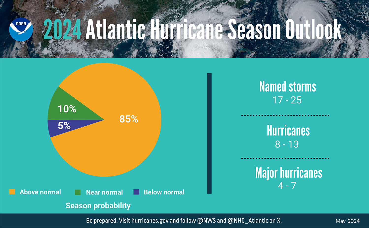
With a week to go before the June 1 start of the 2024 Atlantic hurricane season, the National Oceanic and Atmospheric Administration (NOAA) has released its outlook for tropical activity in the basin.
Unsurprisingly, the agency is predicting above-normal hurricane activity for the 2024 Atlantic hurricane season, which officially runs from June 1 through November 30. Presenting its hurricane season outlook in a series of ranges, NOAA is forecasting a total of 17 to 25 named storms (those with winds of 39 mph. or above). Eight to 13 of those are forecast to reach hurricane strength with sustained winds of 74 mph. or higher. Of those, four to seven are expected to become major hurricanes with winds of 111 mph. or higher.
NOAA officials said they have a 70 percent confidence in those ranges.
In contrast, an average hurricane season has about 14 named storms, seven hurricanes and three major hurricanes.
NOAA attributes the expected above-average hurricane season to “near-record warm ocean temperatures in the Atlantic Ocean, development of La Niña conditions in the Pacific, reduced Atlantic trade winds and less wind shear, all of which tend to favor tropical storm formation,” according to the agency’s May 23 outlook announcement.
“Of course, as you all know, these outlooks do not predict U.S. landfalls, and our recommendations are always the same this time of year,” said Mark Wool, warning coordination meteorologist for the National Weather Service, in an email to stakeholders. “Be prepared, because it only takes one storm to make it a busy season where you live.”
The National Weather Service forecast for the 2024 Atlantic hurricane season tracks closely with the more specific forecast from Colorado State University, which expects to see 23 named storms, 11 hurricanes and five major hurricanes.
Stakeholders of the Gulf Intracoastal Waterway (GIWW) gathered in New Orleans the same day to review the Gulf Coast Inland Waterways Joint Hurricane Response Protocol, a framework for how the maritime industry, U.S. Army Corps of Engineers, U.S. Coast Guard and state and local agencies work together to prepare for impending storms and recovery in the aftermath. The Gulf Intracoastal Canal Association (GICA), led by its president, Paul Dittman, serves as the liaison between the various groups before, during and after a storm.
The plan dates to 2006 and grew out of lessons learned in the 2004 (Ivan) and 2005 (Katrina and Rita) hurricane seasons.
“The protocol really fills in the gaps between the maritime community and the pre- and post-storm response activities and has been extremely successful over the past 17 years,” Dittman said.
Reading an excerpt from the document, Dittman described how the protocol was created for “partnering together to safely and efficiently secure the waterways prior to storm landfall and safely restore them as quickly and efficiently as possible post-storm. The protocol is not intended to supplant or replace any local plans but merely act as the connective tissue which linked them together.”
Dittman described the protocol as a “living document” that is expandable and contractable to meet the needs of any given storm. As such, the only update proposed for the protocol in 2024 was to add a priority list of 14 moveble bridges that cross the GIWW in the state of Louisiana. When those bridges go down, they constrict or effectively close the waterway to navigation. The new appendix within the protocol suggested a priority list to guide and inform post-storm recovery efforts.
Also during the meeting, stakeholders heard from representatives from the Coast Guard throughout the Gulf Coast, the three Corps districts that manage the GIWW and meteorologists from the National Weather Service.
Christopher Bannan, lead forecaster with the National Weather Service’s New Orleans office, overviewed his agency’s products that can aid in preparing for hurricanes. Primarily available on the National Hurricane Center’s website, nhc.noaa.gov, the Weather Service offers short- and long-range storm forecasts, along with flood inundation, wind arrival time and rainfall forecasts.
Bannan said one new feature for National Hurricane Season messaging this year will be intermediate advisories, which will allow the agency to adjust its forecasting more speedily if a storm begins to deviate from the most recent predicted track. Coastal waters will also receive enhanced wave forecasting this year. In addition, some of the agency’s messaging will be broadcast in both English and Spanish this year.
Bannan admitted that high seasonal activity doesn’t always translate to widespread impacts. As an example, he pointed to the 2023 season, the fourth most active hurricane season on record. While 20 storms formed last year, just a handful impacted the U.S. mainland. Still, he echoed the recurrent message from weather forecasters that “it only takes one” storm to make it a busy year for a particular area.


