Rising water on the Lower Mississippi River has triggered the New Orleans Engineer District to activate its Phase II flood fight, with the Carrollton Gage in New Orleans reading 15.6 feet as of April 24 and forecast to reach 16.9 feet by May 1. The New Orleans District activates Phase I flood fight when the Carrollton Gage passes 11 feet. Phase II occurs when the river rises above 15 feet.
Phase II means daily patrols of both banks of the river levee between Baton Rouge, La., and Venice, La. When the river is above 15 feet at the Carrollton Gage, all subsurface construction within 1,500 feet of the levee is suspended.
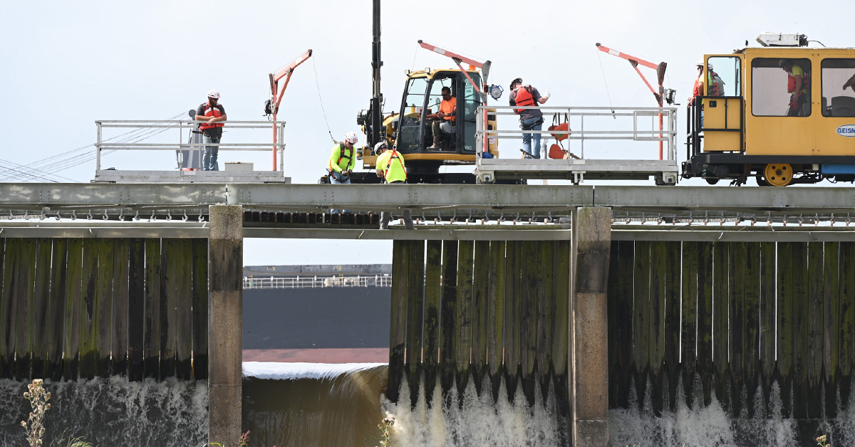
On April 21, officials from the New Orleans District conducted an operational exercise of the Bonnet Carré Spillway, the lowermost flood control structure on the Mississippi River, located in Norco, La. Bonnet Carré is designed to divert a portion of the Mississippi River’s flow into Lake Pontchartrain, 6 miles to the north.
The levees in the vicinity of New Orleans protect the city up to a river stage of around 20 feet, but the trigger point for operating the Bonnet Carré Spillway is a discharge of 1.25 million cubic feet per second, which has historically corresponded to about 17 feet at the Carrollton Gage.
“We look for a flow exceeding 1.25 million cubic feet per second,” said Matt Roe, a public affairs specialist for the New Orleans District, speaking at the April 21 test. “Right now, that is in the forecast. We have not made a recommendation to operate the spillway. However, it’s possible.”
The Bonnet Carré Spillway, built between 1929 and 1931, is made up of around 7,000 beams, or needles, arranged in 350 bays. Corps officials can adjust the amount of water flowing through the spillway by removing or replacing the needles. The spillway, designed to divert up to 250,000 cubic feet per second from the Mississippi River, hasn’t been opened since 2020.
Coast Guard Sector New Orleans sent out an MSIB (Marine Safety Information Bulletin) April 24 alerting vessel operators of guidelines in place when the Mississippi River passes 16 feet on the Carrollton Gage. Towing vessels are advised to not transit between two anchored ships. Towing vessels less than 79 feet long should maintain a minimum freeboard of 1 foot at their lowest point. The Coast Guard also sets a minimum barge-to-horsepower ratio in high water on the Lower Mississippi River of 300 hp. per standard barge and 700 hp. per oversized barge for southbound tows.
“Empty barges may be calculated at 1/2 the horsepower requirements to that of a loaded barge when computing the overall horsepower requirement,” the MSIB stated. “Towing vessels with z-drive propulsion types may be treated as having a horsepower 20 percent greater than the engine’s rating for the purpose of this calculation.”
VTS Lower Mississippi River may approve exceptions on a case-by-case basis.
Northbound vessels must be able to maintain an average speed of 3 mph.
The MSIB also set guidelines for lite boats engaged in a “down streaming” maneuver.
In Baton Rouge, La., with the river gage reading 40 feet and rising, the Coast Guard was requiring all tows entering or exiting Port Allen Lock to use an assist vessel with at least 1,200 hp. In addition, tows topping around between Mile 221 and Mile 235 (between Duncan Point and the Highway 190 bridge) were required to use assist vessels. Ocean-going vessels were also required to use assist tugs when transiting above the I-10 bridge in Baton Rouge.
Elsewhere on the system, the Mississippi River at the confluence with the Ohio River below Cairo, Ill., continues to fall. The National Weather Service’s Lower Mississippi River Forecast Center is forecasting a “broad crest” on the Arkansas River and on the Mississippi River between Natchez, Miss., and Reserve, La., due to additional rain in that region. The forecast currently calls for the Lower Mississippi to be elevated through the middle of May. Baton Rouge is forecast to crest at 41.5 feet on May 1, which would be major flood stage. On the Atchafalaya River, which receives 30 percent of the Mississippi River’s flow at the Old River Control Complex, the National Weather Service is forecasting a moderate flood stage of 7 feet at Morgan City, La., around May 3.


