From SmartPort To Scalable Waterway Intelligence
In December 2022, The Waterways Journal covered The Water Institute’s crowdsourced bathymetry (CSB) and modeling efforts under its SmartPort project—an effort to provide both near real-time and forecast channel conditions. That effort officially concluded in mid-2024, but it laid the foundation for something bigger.
Building on SmartPort’s success in the lowermost Mississippi River, The Water Institute has since expanded its mission, shifting from a focused pilot program to create a scalable effort that can provide comprehensive and timely assessments of available draft and bed elevation conditions throughout the nation’s inland waterway system.
What’s New
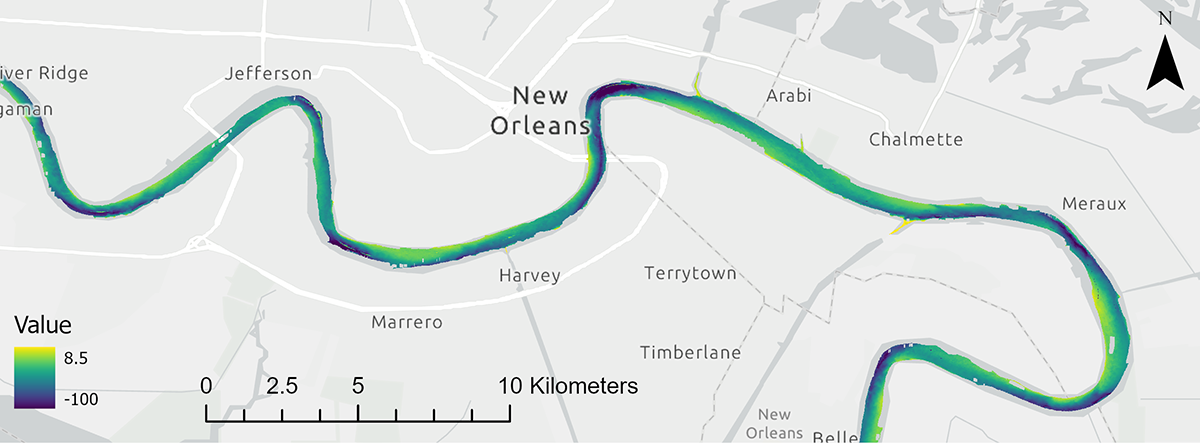
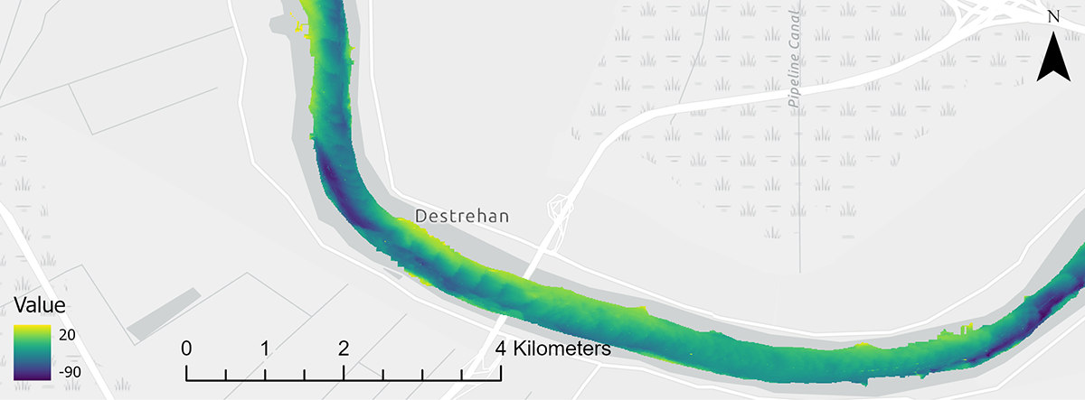
The Water Institute has expanded the geographic scope of its crowdsource effort. While SmartPort initially focused on the Lower Mississippi River, the effort now supports additional reaches of the inland waterway system, including portions of the Gulf Intracoastal Waterway (GIWW), Upper Mississippi River and the Ohio River. In addition, recent advancements in The Water Institute’s data processing workflows have enabled production of detailed maps that can show available draft or bed elevation (see figures 1 and 2).
“The crowdsourced approach and enhanced mapping capabilities offer a novel source of information with the potential to cover expansive areas on a near real-time basis,” said Andrew Courtois, geoscientist for The Water Institute and a lead developer of SmartPort.
By integrating multiple datasets, such as historical surveys and environmental observations from river gauges, The Water Institute has created multiple machine learning models that can forecast channel conditions over varying time horizons (i.e., days to months) at critical locations such as the deep draft crossings on the Mississippi River and within the jurisdictions of the Port of New Orleans and the Port of South Louisiana.
Approximately 80 commercial vessels have participated in the effort, demonstrating how collaboration between science and industry can drive innovation in maritime operations. Participating companies include Crescent Towing, Canal Barge Company, Moran Towing, E.N. Bisso & Son, Bisson Towboat, Harbor Towing & Fleeting and Turn Services. More than 2 billion soundings have been collected, transforming routine vessel movements into a dynamic sensing network.
What’s Next
The Water Institute is deepening its engagement with maritime stakeholders to better understand how its data products can directly improve real-world operations. This includes expanding the crowdsource fleet to increase data density and broaden geographic coverage. These efforts aim to support safer navigation, targeted dredging and survey operations, more efficient cargo and voyage planning, and resilient port and terminal operations.
“As supply chains face mounting pressure from variable waterway conditions and navigational disruption, the demand for real-time and forecast depth data is growing,” Courtois said. “The Water Institute’s crowdsourced bathymetry initiative potentially offers a modern solution to critical challenges in the maritime industry.”
The Water Institute is an independent, nonprofit applied research organization that was founded in 2011 in the aftermath of devastating hurricanes and the 2010 Deepwater Horizon oil spill. The Water Institute’s mission is to reduce the vulnerability of people, communities, ecosystems and economies through transformative approaches to interconnected environmental and social challenges. More information is available at www.thewaterinstitute.org.