

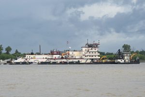
Tow Sizes, Drafts Reduced As Lower Miss Falls
With draft and tow sizes already cut on the Lower Mississippi and little rain in the forecast, the inland navigation industry is preparing for a low-water season that could hit during the peak of fall harvest.
“The forecast doesn’t look good,” said Randy Chamness, chairman of the Lower Mississippi River Committee (LOMRC), the industry committee that works with the Corps and Coast Guard during extreme weather conditions on the Lower Mississippi. “It’s anticipated to slowly fall. The rain we got through the Ohio Valley did give us a little bit of a reprieve, along with some lake releases, but for the most part the river is going to slowly fall.”
With a more drastic fall at Olmsted Locks and Dam than originally anticipated, due in part to little remaining water storage left in lake impoundments on the Tennesse and Cumberland rivers, LOMRC has worked in conjunction with Sector Lower Mississippi to reduce drafts even more starting September 7. Drafts are set at 10 feet maximum from Cairo, Ill., southbound to Greenville, Miss. (Mile 537), 10 feet, 6 inches from Greenville southbound to the Gulf of Mexico, and 9 feet, 6 inches for northbound tows between the Gulf of Mexico and Cairo.
Maximum tow widths were set at six barges wide between Cairo and Greenville and seven wide from Greenville south.
Problem Areas
Three big areas of concern on the Lower Mississippi were at Williams (Mile 928), The Interstate 40 bridge at Memphis (Mile 737) and Tarpley (Mile 541), Chamness said.
Since August 31, the dredge Potter has been dredging in the vicinity of Williams, between miles 928 and 931, which is roughly between the cities of Wickliffe and Hickman along the Kentucky side of the river, Chamness said.
That dredging has been accompanied with rolling 24-hour closures, during which the queue has been building to an average of 20 to 25 boats, he said.
Chamness noted that the channel in that area had been slowly deteriorating, with a lot of places reaching 11 to 12 feet in depth. Following the completion of dredging in that segment, the dredge Potter will return to the St. Louis District, he said.
Seven miles away, at Mile 921, mariners had “a couple of bump and goes” on the bedrock bottom just outside of Hickman. Since dredging is not possible because of the bedrock, the Coast Guard planned to transition the channel to the other side of the river.
“We think we’ve got a deep-water path through there,” Chamness said.
However, a minor mechanical issue with the cutter Chena meant it was not operational and was causing delays in moving those buoys, he said.
The dredge Hurley departed the deep-draft portion of the river south of Baton Rouge on September 4 to mobilize to the Tarpley area, near Greenville. It was expected to take three or four days to relocate, with a plan to start 24-hour closures upon its arrival in the area.
“That seems like one of the more critical areas for us based on what we’re seeing now,” Chamness said.
The dredge Jadwin had completed one 24-hour closure near the I-40 bridge in Memphis and expected to complete another 24 hours of dredging after clearing the queue before the Memphis Engineer District’s mat-sinking unit started its scheduled work in the Sunrise area at Mile 775. That work is expected to take five days with closures to southbound traffic from 6 a.m. to 6 p.m. daily.
“With the Potter, the Hurley and the Mat Sinking Unit, we’ve got three closures within 200 miles of each other, which has been a challenge to work through,” Chamness said.
He anticipated the next areas where dredging might be needed to be Stack Island (Mile 486), Lakeport (Mile 525) and Laconia (Mile 618), according to channel survey data.
Along with dredging, Chamness stressed the continued importance of timely placement of buoys to mark the channel. He said industry is working with the Coast Guard to help run a normal schedule for cutters.
“So far they’re doing a very good job,” he said.
Saltwater Intrustion
The New Orleans Engineer District announced it would begin construction September 10 on an underwater sill across the bed of the Mississippi River at Myrtle Grove (Mile 64) in Plaquemines Parish, La.
The sill, made from dredged sediment, is designed to prevent an underwater wedge of saltwater from making its way upriver from the Gulf of Mexico, threatening municipal and industrial water intakes. The Corps said it will take about two weeks to construct the sill once a contract is awarded and the dredge mobilized.
The district said August 29 that based on current river conditions and forecasts, the toe of the saltwater wedge is expected to reach River Mile 80 Above Head of Passes within the next 28 days, triggering construction of the underwater sill.
The intrusion of salt water into the river is a naturally occurring periodic condition because the bottom of the riverbed between Natchez, Miss., and the Gulf of Mexico is below sea level. Denser salt water moves upriver along the bottom of the river beneath the less dense fresh water flowing downstream. Under normal conditions, the downstream flow of the river prevents significant upriver progression of the salt water. However, in times of extreme low volume water flow, unimpeded salt water can travel upriver and threaten municipal drinking water and industrial water supplies.
This will be the third year in a row that the Corps has constructed the sill. Previously, it was considered a once-a-decade operation. Similar sills were built in 1988, 1999, 2012, 2022 and 2023.
The sill will be maintained until river flows increase and push the salt water downstream. At that point, the increased river flow will naturally erode the feature.
Upper Mississippi, Ohio
The Upper Mississippi was in better condition, according to Bernie Heroff, chairman of the River Industry Action Committee, which works with the Corps and Coast Guard to manage the Upper Mississippi during periods of high and low water.
The St. Louis gage was at 3.6 feet on September 3 and forecast to fall to zero at the end of September. That’s about three feet above the Low Water Reference Plane of –3.2 feet, “so we appear to be good to the first week of October,” Heroff said.
He added, “We may see some shoaling on the very lower end of the Upper Mississippi River with the extremely low stages forecast for Cairo. If the weather stays dry, we may have more challenges from St. Louis to Cairo by mid-October.”
Lower Mississippi River restrictions are limiting the loading drafts for the St. Louis area, he said.
Additionally, the Corps is doing a lot of dredging above St. Louis, which is so far keeping traffic moving as the river slowly falls, Heroff said.
The Coast Guard sent out a notice September 3 saying the dredge David J. Bangert was dredging on the Upper Miss between Miles 240 and 240.6, with dredging expected to continue from 6 a.m. to 3 p.m. through September 6.
Another notice sent out the same day indicated the dredge Angela Kay planned to operate 24 hours a day Monday to Friday at Upper Mississippi Mile 713.8.
On the Ohio River, the Coast Guard sent out a notice September 4 that the dredge Bill Holman was operating between Mile 969 and Mile 975. The dredge may be in the navigation channel, and the disposal pipeline may be crossing the channel, requiring the pipeline to be opened for the passing of traffic, the Coast Guard said.
Forecast
Looking at the long-range forecast, Chamness expressed more concern. He noted that toward the middle of the month the Memphis gage is expected to fall to around -8 feet, which would require more draft cuts. The ideal stage on the Memphis gage is 10 to 15 feet, he said.
While last year’s low-water season started in June, Midwest flooding and the remnants of Hurricane Beryl pushed this year’s low-water season out until the beginning of August, Chamness said.
Unfortunately, he said, the timing is not ideal, with harvest in the Delta areas already beginning and Midwest harvesting on track to begin by the end of September.
“Since we’re entering the early stages of harvest, there’s a lot of pressure to move boats and barges,” Chamness said. “That’s on everybody’s mind. While we dredge and do channel maintenance, our top concern is continuing to move traffic in a market that’s really heating up.”